Mount Pleasant Township, Adams County, Pennsylvania
Mount Pleasant Township, Adams County, Pennsylvania | |
|---|---|
 John's Burnt Mill Bridge, a historic site in the township | |
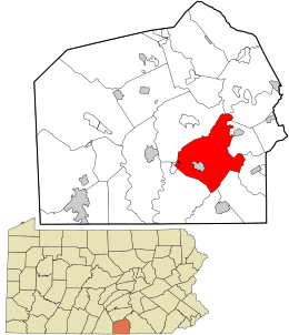
 Location in Adams County and the state of Pennsylvania. | |
| Country | United States |
| State | Pennsylvania |
| County | Adams |
| Settled | 1730 |
| Incorporated | Before 1800 |
| Area | |
| • Total | 30.58 sq mi (79.20 km2) |
| • Land | 30.41 sq mi (78.77 km2) |
| • Water | 0.17 sq mi (0.44 km2) |
| Population | |
| • Total | 4,667 |
| • Estimate (2023)[2] | 4,730 |
| • Density | 154.71/sq mi (59.73/km2) |
| Time zone | UTC-5 (Eastern (EST)) |
| • Summer (DST) | UTC-4 (EDT) |
| Area code | 717 |
| FIPS code | 42-001-51776 |
Mount Pleasant Township is a township that is located in Adams County, Pennsylvania, United States. As of the 2010 census, the township population was 4,693.[3]
It includes an exclave of the Gettysburg National Military Park.[4]
Geography
[edit]According to the United States Census Bureau, the township has a total area of 30.6 square miles (79.2 km2), of which 30.4 square miles (78.8 km2) is land and 0.15 square miles (0.4 km2), or 0.56%, is water.[3]
Demographics
[edit]| Census | Pop. | Note | %± |
|---|---|---|---|
| 2000 | 4,420 | — | |
| 2010 | 4,693 | 6.2% | |
| 2020 | 4,667 | −0.6% | |
| 2023 (est.) | 4,730 | [2] | 1.3% |
| U.S. Decennial Census[5] | |||
As of the census[6] of 2000, there were 4,420 people, 1,616 households, and 1,258 families residing in the township.
The population density was 144.3 inhabitants per square mile (55.7/km2). There were 1,681 housing units at an average density of 54.9 per square mile (21.2/km2).
The racial makeup of the township was 98.44% White, 0.43% African American, 0.14% Native American, 0.38% Asian, 0.34% from other races, and 0.27% from two or more races. Hispanic or Latino of any race were 1.70% of the population.
There were 1,616 households, out of which 36.6% had children under the age of eighteen living with them; 65.6% were married couples living together, 6.7% had a female householder with no husband present, and 22.1% were non-families. 17.6% of all households were made up of individuals, and 7.4% had someone living alone who was sixty-five years of age or older.
The average household size was 2.74 and the average family size was 3.08.
Within the township, the population was spread out, with 26.8% of residents who were under the age of eighteen, 7.6% who were aged eighteen to twenty-four, 29.9% who were aged twenty-five to forty-four, 23.9% who were aged forty-five to sixty-four, and 11.8% who were sixty-five years of age or older. The median age was thirty-seven years.
For every one hundred females there were 100.6 males. For every one hundred females who were aged eighteen or older, there were 98.2 males.
The median income for a household in the township was $41,132, and the median income for a family was $44,619. Males had a median income of $30,313 compared with that of $21,806 for females.
The per capita income for the township was $16,913.
Approximately 7.2% of families and 9.9% of the population were living below the poverty line, including 17.2% of those who were under the age of eighteen and 5.5% of those who were aged sixty-five or older.
Education
[edit]Most of the township is in the Conewago Valley School District, while a piece is in the Littlestown Area School District.[7]
References
[edit]- ^ "2016 U.S. Gazetteer Files". United States Census Bureau. Retrieved August 11, 2017.
- ^ a b c Bureau, US Census. "City and Town Population Totals: 2020-2023". Census.gov. US Census Bureau. Retrieved October 30, 2024.
{{cite web}}:|last1=has generic name (help) - ^ a b "Geographic Identifiers: 2010 Demographic Profile Data (G001): Mount Pleasant township, Adams County, Pennsylvania". U.S. Census Bureau, American Factfinder. Archived from the original on February 12, 2020. Retrieved July 19, 2013.
- ^ "2020 CENSUS - CENSUS BLOCK MAP: Mount Pleasant township, PA" (PDF). U.S. Census Bureau. Retrieved October 19, 2024.
Gettysburg Natl Mil Pk
- ^ "Census of Population and Housing". Census.gov. Retrieved June 4, 2016.
- ^ "U.S. Census website". United States Census Bureau. Retrieved January 31, 2008.
- ^ "2020 CENSUS - SCHOOL DISTRICT REFERENCE MAP: Adams County, PA" (PDF). U.S. Census Bureau. Retrieved October 19, 2024. - Text list


